Choctaw French Sources
Let's take a break from Romans and go back in time a few years to his West Florida forebears, the Louisiana French. We should note that most of the Choctaw/French relations were administered from Mobile. The seat of French Louisiana government moved from Mobile to New Orleans in 1719-21 but most of the administration of the Choctaw, Chickasaw and Creek Nations including trade were conducted from Mobile until 1763.
Mississippi Provincial Archives, French Dominion (MPAFD)
Volumes I, II and III were collected, edited and translated by Dunbar Rowland and A. G. Sanders. There are five volumes of MPAFD; the first three volumes are available on-line courtesy of the University of California HathiTrust Digital Library. Volume I was published in 1927, some twenty-five years after Halbert's Choctaw village papers. From Volume I, we provide four French journals dating 1729-1733. As you read the Journals, you will note that the Choctaw villages' alternative names, village meanings and locations were mostly attributed by Rowland and Sanders footnotes to Halbert and Brown. Also, note that a number of the Journals and letters were addressed to Maurepas, Jean-Frederic Phelypeaux, Count of Maurepas and Minister of the Navy.
Note the on-line California HathiTrust text possesses two page counters, the higher number represents all the pages including cover sheet, forward, Table of Contents, etc. We reference the book pages or the lesser of the two numbers. Should you loose your link, we suggest you search "Mississippi Provincial Archives" and select from the list provided by HathiTrust.
The following Journals are included in MPAFD Volume I.
Regis du Roullet Journal I
MPAFD I 17-54 page: The instructions from Governor Perier to Regis du Roullet start page 17 and date August 21, 1729 while the Journal begins page 21. The author, Regis du Roullet, soldiered in the French cavalry for six years prior to transferring to Louisiana in 1724. He served as an ensign under Diron (Mr. Diron in the Journal) d'Artaguiette at Fort Toulouse (near present day Wetumpka, Alabama) before becoming a second lieutenant under Captain Lusser's (you will meet him in the next Journal) company at Mobile.
Roullet was sent to the Choctaws by Governor Perier with eight hundred pounds of presents to meet with the Choctaw headmen and distribute the presents while completing a set of nine written instructions. Perier desired to provide the Choctaw with better priced goods, as competitive as the British traders. Roullet was also to find a location for a trading house to better serve the Choctaw who traded with d'Artaguiette's traders in their villages or visited Mobile for annual presents, trade deerskins, barter services, claim Chickasaw scalps for bounty and obtain gunsmithing and blacksmithing services. Additional information about Governor Perier may be found on my Chickasaw website within a Musing: Were the French Distracted? Perier is number 17 on the first two lists on that page.
You will note that when Roullet reached Mobile, he immediately had issues with Diron d'Artaguiette, the King's Lieutenant, who did not want to provide a horse, porters, etc. You would think that with Roullet under orders from the Governor that Diron d'Artaguiette would help as much as possible. However, d'Artaguiette knew that the Governor was looking to end his exclusive trade contract with the Choctaw and Chickasaw. Additional information about Diron d'Artaguiette may also be found on my Chickasaw website within a Musing: Were the French Distracted? Diron d'Artaguiette is number 10 on the first two lists on that page.
At last, Roullet received assistance and started his journey to the Choctaw villages which he recorded in detail. He also noted his talks with the Choctaw leaders, the villages he visited, the paths he took and the creeks that he crossed. We suggest you read his journal with an opened Choctaw village map (links to Cresnay map below). Roullet finished his Journal October 29, 1729, and it was mailed to France via ship to Minister of the Marine Maurepas November 11, 1729. On pages 41-44 Regis du Roullet provided a partial list of Choctaw villages and those Choctaw leaders whom he gave presents. Note Mingo Tchito was the Great Chief of the Choctaws who lived at Couechitto (Aloue), Village of the Great Chief MPAFD I 41.
Joseph Christophe de Lusser Journal
Lusser's journal began January 12, 1730, see MPAFD I 81. From the journal's beginning you understand that Lusser was being protected by soldiers and guided by Choctaw to the Choctaw Homeland. Why? On November 29, 1729 (about a month after Regis du Roullet's Journal I ended) Louisiana exploded. The Natchez revolted against the French at Fort Rosalie (Natchez, Ms) and massacred more than two hundred French men, women and children. To be sure there were survivors (mostly women and children) whom the French desperately wanted to find and claim. As you read, there are other French survivors, Negro slaves, who the French also claimed. The problem was the Choctaw, who had helped the French attack the Natchez after the revolt, wanted them too. Joseph Christophe de Lusser was a Swiss French Captain at Mobile where he headed a company including a half company of Karrer (Swiss) grenadiers. When Lusser arrived in the Choctaw Homeland, he immediately wrote Governor Perier a letter letting him know that the Choctaws had indeed left their villages to attack the Natchez. Lusser remained in the Choctaw Homeland awaiting further orders and writing letters as needed to give his superiors current information from the field. The French were starved for information about the Nathez, their location, attacks by the Choctaw and French survivors. Additional information about Lusser may be found on my Chickasaw website within a Musing: Were the French Distracted? Lusser is number 6 on the first two lists on that page.
Lusser's journal entries indicated that he was exceptionally attentive to the landmarks that he visited on his route from Mobile to and among the Choctaw villages, particularly the creeks and swamps. He also provided descriptions of several Choctaw villages. He closed his journal on March 22, 1730. On MPAFD I pages 116 and 117 Lusser provided tables of the Eastern Part page 116, Western Part page 117 of Choctaw villages with estimated populations and the three Choctaw villages very near Mobile as "Choctaws Established on the Mobile River." Note on both pages Lusser provided parentheses to group the dependencies of the principal villages located above. Note on page 117 the first line of villages are Ouskelagana (Oskilakna) (or Yellow Canes) and Cheniacha. Under them are six dependent villages. A few years later the French and then the British will call this group Sixtowns or Six Villages. In the Choctaw Homeland proper, including the Sixtown villages, Lusser provided the names and populations (Men bearing arms) of 44 Choctaw villages.
Regis du Roullet Journal II
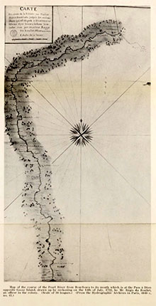 The second Choctaw journal of Regis du Roullet began in Mobile in April 1732, see MPAFD I 136. The purpose of his trip to the Choctaw Homeland was to survey the Pearl River. His map is shown following MPAFD I 154. He visited several villages that he had not visited in Journal I. Before having a pirogue made by a Choctaw near the Pearl River, Roullet built a fort for his small French contingent as there were reported Natchez and their allies, the Chickasaw, about. He also added a group of Choctaws from neighboring villages to patrol for prospective, lurking enemies. The journal closes with Roullet approaching New Orleans. At the end of the journal August 10, 1732 on pages 150-154 Roullet provided tables of Choctaw village names, meaning of village names, number of warriors in each village and names of the chiefs. There are 51 named villages divided into three groups: Western, Eastern and Center. The villages that will become known as the Six Villages or Towns are listed in the Western Part on page 150. Couechitto, the Grand Village, is listed in the Center group.
Regis du Roullet Journal III
On pages 170-192 of MPAFD I resides a collection of Regis du Roullet (Roullet) Journal entries. This collection includes entries from Journals I and II as well as several not included. This collection was sent by letter from Regis du Roullet to Maurepas. Why the repetition? When Bienville returned as Governor of Louisiana in 1733, thus replacing Governor Perier, he forced Roullet to resign his commission in order to return to France. The letter and its journal entries served to remind Maurepas of the exemplary service that Roullet provided the crown. Note that Roullet recorded Lusser's activities in the Choctaw villages. Additional information about Governor Bienville may be found on my Chickasaw website within a Musing: Were the French Distracted? Bienville is number 13 on the first two lists on that page.
This journal was sent via ship to Maurepas from New Orleans about April 1733. The last page explained to Maurepas, Roullet's predicaments with Governor Bienville. He was accused of having a dalliance or at least the affections of Madame de Cremont whose husband was the Commissariat of Mobile.
Taken as a group, the Journals add flesh, breathe life and stimulate images of the Choctaw Homeland including its people, their villages, paths and streams.
Let's look at French maps, sources that show locations of the Choctaw villages, visited by Regis du Roullet and Joseph Christophe de Lusser.
Cresnay (Crenay) Map 1733
The Cresnay (Crenay) map was produced by Henri de Poilvilain Baron de Cresnay in Mobile 1733. You will find his biography on Wikipedia. Additional information about Baron de Cresnay may be found on my Chickasaw website within a Musing: Were the French Distracted? Cresnay is number 15 on the first two lists on that page.
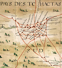 The alert reader remembered him as Baron de Crenay in Regis du Roullet's Journal III above. The Cresnay map Carte de Partie de la Louisiane... showed the extent of Louisiana including New Orleans, Mobile and several Indian peoples' villages, notably the Choctaw villages or "PAYS DES TCHACTAS." The Choctaw villages are named on the map and their location represented by symbols of Indian dwellings or huts. The more prominent villages have larger letters and symbols. Paths are shown as red lines. The map is courtesy of Archives Nationales d'Outre-Mer Aix-en-Provence. Forty-seven Choctaw Homeland villages are shown. In addition the three villages noted by Lusser Journal MPAFD I 117 "Choctaws Established on the Mobile River" are shown north of Fort Conde "Thome" and "Naneaba" and south of Fort Conde "Chacheaux" of Mobile proper. The Choctaw villages' names and their respective locations on the map were likely taken from the Roullet and Lusser Journals and interviews. The map indicates the path from Mobile to the Choctaw villages described by Roullet and Lusser. On that path are two southern villages that are prominent in the journals: "Youane" and "Chica-chae" (also spelled Chickasawhay). Note west and north of Chica-chae are the Six Nations or Villages: "Boutouloukehe", "Nachoubaouanja", "Seneacha", "OuskeLacana" or Yellow Canes, " Tala" and "Talapoucta." Additional map information is recorded on a Musing: Cresnay (Crenay) Map on thechickasawvillages website which provides information on proper map names about Mobile and Mobile Bay environs. I am not aware that Halbert knew of this map or the Choctaw village names provided.
How accurate is the map for locating Choctaw villages? We find the locations at best relative particularly for neighboring villages.
Broutin, Verges and Saucier (BVS) Maps 1740 and 1743; Broutin Map circa 1743
Ignace Francois Broutin was one of the most distinguished of the French officers in Louisiana. At the end of his career he was titled Royal Engineer of the King and had been awarded the coveted Order Saint Louis. Broutin served as a cartographer, engineer, field officer, land cession director and plantation owner. Additional information about Broutin may be found on my Chickasaw website within a Musing: Were the French Distracted? Broutin is number 19 on the first two lists on that page.
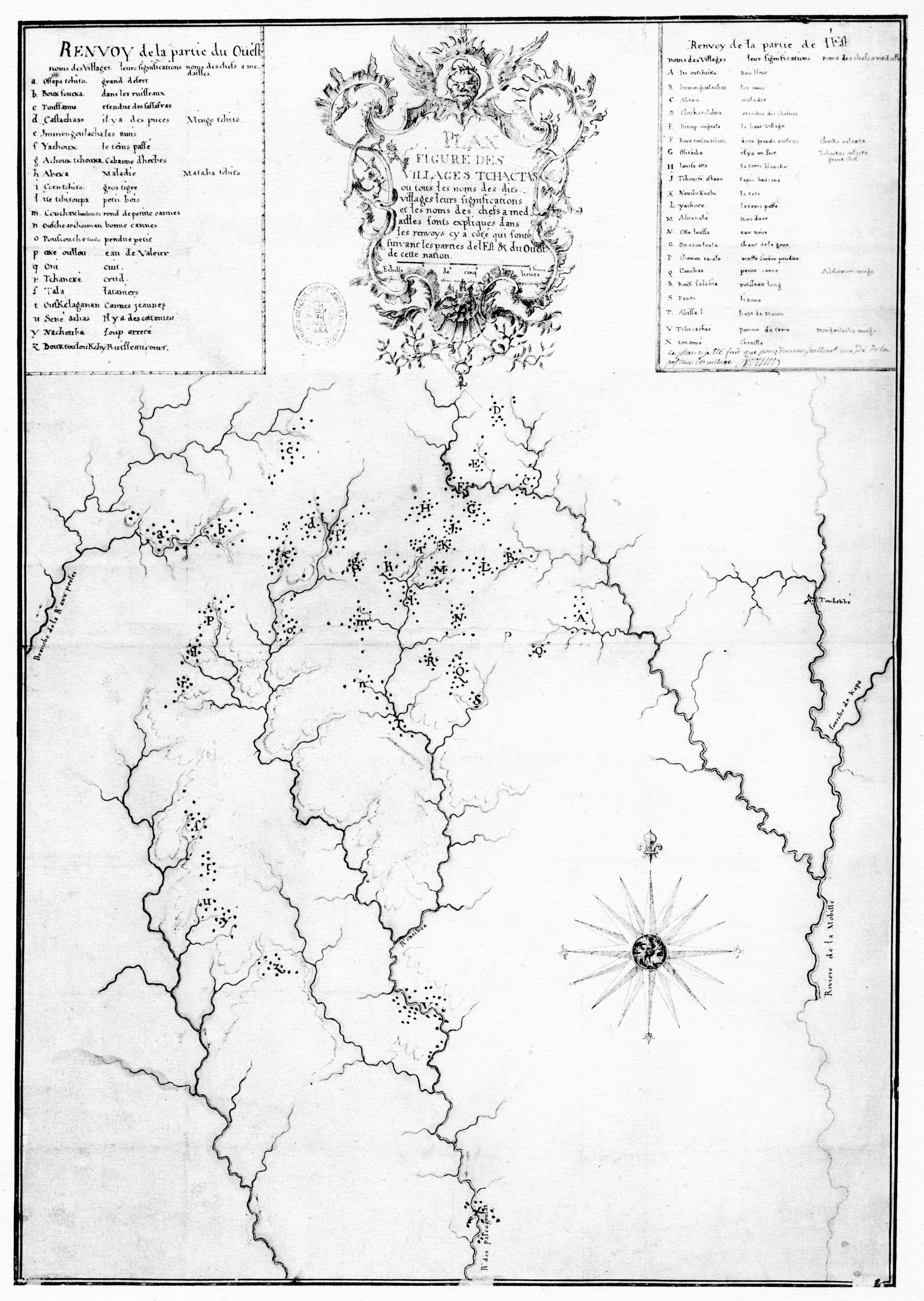 The Broutin Map circa 1743 FIGURE DES VILLAGES TCHACTAS is courtesy of Research Laboratories of Archaeology The University of North Carolina at Chapel Hill. It documented 42 Choctaw villages in the Homeland. The map divided the villages of the west represented by small letters and those of the east with large letters. By example, "Boukfoucka" the village near where Regis du Roullet began his mapping of the Pearl River is "b." "Conchas" or Coosa, one of the prominent villages of the east is "Q."
Note creeks and rivers are shown but their position and physical setting are generally lacking, compared to the Romans Map 1772. The Tombigbee River is labeled "Rivierre de la Mobille" on the east side of the Broutin Map circa 1743. Above that is Fort Tombeckbe "Tombekbe." The Tombigbee River below the fort is drawn incorrectly. Oddly, Broutin surveyed the Tombigbee river in 1737-38 and produced a map with Bernard de Verges and Francois Saucier (BVS) in June 1740, BVS Map 1740. The purpose of that map was to find the best and shortest route from the Mississippi River to the Chickasaw Villages. The BVS Map 1740 is courtesy of Research Libraries of Archaeology University of North Carolina Chapel Hill. This map was a portion of a larger map produced by Broutin, de Verges and Saucier also dated 1743 concerning the French Chickasaw War of 1739-40.
 The later map we will call the BVS Map 1743, which is available courtesy of the Library of Congress. Notice the BVS Map 1740 and the BVS Map 1743 transect the northern Choctaw Homeland including a dozen or so villages and paths. Are the Broutin Map circa 1743, or the BVS Map 1740 or the BVS Map 1743 correct with respect to the Choctaw villages' locations? We will discuss this later.
Mississippi Provincial Archives, French Dominion (MPAFD)
Previously we introduced Volumes I, II and III which were collected, edited and translated by Dunbar Rowland and A. G. Sanders. There are in fact two other volumes, IV and V, which were collected, edited and translated by Dunbar Rowland and A.G. Sanders and revised and edited by Patricia Kay Galloway, Louisiana State University, Baton Rouge and London, 1984. Regrettably, these volumes are not available as pdf. They are for purchase via Amazon, etc. or available for reading at most larger libraries.
That said, our focus will be Volume V, 1749-1763; specifically the Choctaw Civil War 1747-1750. As you may recall from reading the Journals of Regis du Roullet and Joseph Christophe de Lusser (above) each had tables of the village names and a division of those villages into two or three parts. The Journals dated 1729-1733. What did you miss from 1733 to 1749? Let's see . . . the French under Governor Bienville lost two battles in the Chickasaw War 1736, and a drawn out Chickasaw War 1739-40 which did not cause a great loss of life on the battlefield but consumed huge amounts of funds and time. With three major losses Bienville was removed from office, returned to France, never to return. I should add that despite Bienville forcing Regis du Roullet to resign from the King's service in order to travel to France, Roullet did make it back to France and was allowed to rejoin the French army. Joseph Christophe de Lusser was killed at what is now Tupelo, Ms in Chickasaw War of 1736 Battle of Ackia. Red Shoe of the Cushtushas, who from the French perspective fostered the Choctaw Civil War 1747-1750, was killed by a Choctaw in 1747 to collect a French bounty. There are excellent biographies of Red Shoe on Wikipedia and the Mississippi Encyclopedia.
MPAFD V 13 opened with the Choctaw Civil War in full swing. Vaudreuil, Pierre de Rigaud, Marguis de Vaudreuil-Cavagnial, was governor of Louisiana. His letters to France provided detailed information about Civil War rebel and ally Choctaw villages and their leaders. (In order to follow the letters and their frequent village names the reader may want to open Cresnay Map 1733 and Lusser's list of Choctaw villages, MPAFD I 117-8). Generally the Western Part of the Choctaw Nation was allied with the British, identified as Rebels. Rebel villages noted by Vaudreuil included: Boucfouca, Okeoulou, Couechitto, West Abeca, Tchanke, Oni, Tala, West Immongoulacha, Caffetalaya and Cushtusha. Vaudreuil also noted the allied villages which included: Yowani, Okalusa, Yanabe, Chickasawhay, Concha (Coosa), Epitoupougoula, Chichatalaya, Bouctoucoulou Chitto, Nachoubaouenya, Yellow Canes, Senachas and East Abeka.
#/media/File:De_batz_tchaktas.jpg) Far and away Couetchitto was the most surprising of the Rebel villages. Recall on Lusser's list 1730 Couechitto was not only the Great Village of the Choctaw but also a member of the Eastern Part. Couechitto was destroyed per the French. For their part, the French encouraged the Choctaw to kill British traders, take their horses and steal their trade goods. To stimulate their allies to war, the French also paid a bounty for Rebel Choctaw scalps. Vaudreuil bragged that the bounty for a rebel Choctaw scalp was three times the value for a Chickasaw scalp MPAFD V 16. In 1750 the French brokered a four part peace, MPAFD V 58. Alibamon Mingo and other chiefs gave speeches to facilitate peace.
Far and away Couetchitto was the most surprising of the Rebel villages. Recall on Lusser's list 1730 Couechitto was not only the Great Village of the Choctaw but also a member of the Eastern Part. Couechitto was destroyed per the French. For their part, the French encouraged the Choctaw to kill British traders, take their horses and steal their trade goods. To stimulate their allies to war, the French also paid a bounty for Rebel Choctaw scalps. Vaudreuil bragged that the bounty for a rebel Choctaw scalp was three times the value for a Chickasaw scalp MPAFD V 16. In 1750 the French brokered a four part peace, MPAFD V 58. Alibamon Mingo and other chiefs gave speeches to facilitate peace.
What caused the Choctaw Civil War? The quick answer was the high prices the French demanded for their trade goods, and the inferior quality of those goods, compared to the British. The Choctaw complained about both for decades. If the French prices had been reduced and the quality improved, the British would not have traveled to the Choctaw villages to trade. Red Shoe would not have had a reason to bring the British into the Choctaw villages. The Choctaw Civil War was not the end of the French in Louisiana but the attention of the French crown was diverted from its colonies due to wars on the Continent. In Louisiana communication and the attention of the Crown became increasingly diverted by Seven Years War, 1756-1763. Nor was the Civil War the end of the Choctaw. There were splits and divisions in villages; the rifts took time. The number of Choctaw villages increased. In 1750 there were 42 villages reported, MPAFD V 59; MPAFD V 194 noted 52 villages in 1758. Romans' Map of 1772 listed 60 villages with one destroyed in the Civil War. The Choctaw also had a new, old enemy- the Upper Creeks, particularly the Abehkas and Talapoosa.