British Sources for the Choctaw Villages
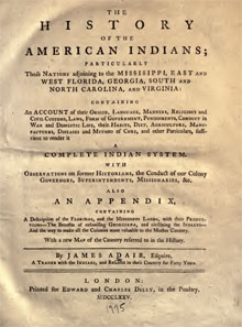
James Adair British Trader and Author
As regards the Choctaw villages, Adair answered several questions. We learned in MPAFD V 18 that Couechitto, the Great Village of the Choctaws, was attacked and burned in the Choctaw Civil War. Adair page 296, "he came to Quansheto, where the towns-people of the late Great Red Shoe had settled . . ." Quansheto was Adair's spelling of Couechitto. Apparently, Red Shoe and his supporters had moved from Cushtusha to Couechitto where they experienced the French Civil War faction's wrath. The French touted that Couechitto was destroyed and the head of its chief given to them, see MPAED 16.
What role did Adair play in the Choctaw Civil War? He addressed Red Shoe of the Cushtushas 12 times in his book. On page 296 Adair called him, "the late Great Red Shoe." That speaks volumes about Adair's role and relationship.
Mississippi Provincial Archives, English Dominion (MPAED)
Volume I was collected compiled and edited by Dunbar Rowland; printed Nashville 1911. There is one volume of MPAED spanning in time 1763-1766; courtesy of the University of California HathiTrust Digital Library. The British, long the French enemy internationally and in Louisiana, with the strokes of several quills (Treaty of Paris February 10, 1763) gained control of territory that would be called British West Florida and all French claims east of the Mississippi River (excluding the Island of Orleans (New Orleans). The British Dominion entries consisted largely of letters to the Secretary of State in London.
Taking control of former French property and holdings was the first order of the day for the British in former Louisiana. In November 1763 a British officer from Fort Tombecbe sent his superior in Mobile a list of Choctaw villages, Chiefs and Number of inhabitants which was written in French, see MPAED (book page) 26. The document listed 50 Choctaw villages excluding the two villages near Mobile. Was the source of the list of Choctaw villages the soon to be hired French Choctaw interpreter Favre from Mobile?
MPAED also includes the Councils between the Indian Nations and British Major Farmer and French Governor d'Abbadie of New Orleans. The Chickasaw and Choctaw Council were held jointly at Mobile, see MPAED 83. Following the Councils, formal Congresses were held in Pensacola with West Florida Governor George Johnstone and his Indian Superintendant John Stuart. Again the Chickasaw and Choctaw met together, see MPAED 215. The Congress took several days and each chief could speak. Several Choctaw Chiefs spoke. Prices of trade goods were fixed and were the same for the Chickasaw and Choctaw. The British recognized three divisions of the Choctaw: the Great Party (formerly French allied in the Choctaw Civil War), the Small Party and the Six Villages (Adair's lower villages). The MPAED closed with Creek Indians issues: they have murdered British subjects, stolen cattle and accosted British traders.
Edmond Atkin Indian Merchant, Superintendent and Author
Rather than administering their new French lands from their colonies of South Carolina and/or Georgia, the British created two new colonies of East and West Florida. The British also established an Indian Superintendent to conduct and manage trade and relations with the Indian peoples. This included the major tribes of the Creek, Choctaw and Chickasaw as well as the smaller Nations. What led to these changes in administration was a document written by Edmond Atkin.
Edmond Atkin (1707- 1761) was a British-born, Charleston merchant who traded in Indian merchandise. He was awarded a seat on the Governor of South Carolina's Governor's Council in 1738 which in part dealt with Indian trade and traders issues. Atkin perhaps due to his commerce with Indian traders wrote two papers of note. The first in 1753 regarded the Choctaw Civil War: Historical Account of the Revolt of the Chactaw Indians . . . London January 20, 1753, furnished by the University of Memphis University Libraries Digital Commons Special Collections Publications as a download. The document begins a few pages inside. To my knowledge the document has not been transcribed. Atkin did journey to the frontier and met several Choctaw. However, those activities were made after the first work was dated. Atkin second work, The Edmond Atkin Report and Plan of 1755 linked from from HathiTrust Digital Library, presented a plan to handle the affairs of and regulate Indian trade outside the framework of the Governors of the English Colonies. The edited work was titled Indians of the Southern Colonial Frontier; the Edmond Atkin Report and Plan of 1755; Edited with an Introduction by Wilbur R. Jacobs; University of South Carolina Press, Columbia S.C, 1954. The Report and Plan were well received as Edmond Atkin was appointed Indian Superintendent of the Southern District in 1756. To be kind, James Adair knew Edmond Atkin and did not agree with his policies. Adair shared his displeasure in his book, The History of the American Indians.
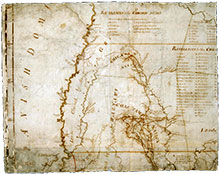
Romans, Bernard; Taitt, David; Gauld, George (RTG) West Florida Map of 1773
.jpg) Apparently the original Romans' A Map of West Florida 1772 that Gatschet copied is lost. The 1773 map is titled "A Map of West Florida and Part of Et: Florida, Georgia, and Part of So. Carolina", and is provided courtesy of Research Libraries of Archaeology University of North Carolina Chapel Hill. This map approximates Romans' 1772 original. There are still creek location issues but better scale than that of Gatschet. There are 60 villages listed in the rectangular box above the Choctaw villages; however, two were deserted and one was destroyed in the Choctaw Civil War. The other striking feature is there is little of the country around the Choctaw mapped. The Choctaw villages are relatively easy to see as are the major paths that connected them. Hereafter, we will call this map RTG Map 1773.
Apparently the original Romans' A Map of West Florida 1772 that Gatschet copied is lost. The 1773 map is titled "A Map of West Florida and Part of Et: Florida, Georgia, and Part of So. Carolina", and is provided courtesy of Research Libraries of Archaeology University of North Carolina Chapel Hill. This map approximates Romans' 1772 original. There are still creek location issues but better scale than that of Gatschet. There are 60 villages listed in the rectangular box above the Choctaw villages; however, two were deserted and one was destroyed in the Choctaw Civil War. The other striking feature is there is little of the country around the Choctaw mapped. The Choctaw villages are relatively easy to see as are the major paths that connected them. Hereafter, we will call this map RTG Map 1773.
Purcell, Joseph; Stuart, John Map of 1775
Joseph Purcell (1750-1806) was Irish surveyor who served in South Carolina. He immigrated to the colony of South Carolina in 1765 and served as an apprentice cartographer and surveyor. Afterwards, he served under John Stuart, head of the Southern District of the British Indian Department in Charleston. (Source: Geographicus Rare Antique Maps).
 The 1775 map is titled, A Map of the Southern Indian District of North America, courtesy of CARLI (Courtesy of Academic and Research Libraries in Illinois) Digital Collections. The link is to Sheet 4 of the 1775 Purcell map which includes the Choctaw villages; the total map encompasses 13 sheets. The Village names and associated map numbers are shown on Sheets 4 and 5. Note there are 57 listed villages which is less than the 60 villages in the Romans Map 1772. The map appears very similar to RTG Map 1773. However, it is incomplete as the Sixtown villages are not accounted for on the map. Overall, the map is hard to read as the ink has oxidized bleeding and blending in with the paper. The ink numbers on the map are blurred and difficult to focus. We are not aware that Halbert was aware of this map. Compared to Romans Map 1772 this map provides more detail of the path system connecting the Choctaw villages and their environs. We will call this map: Purcell Stuart Map 1775.
Purcell, Joseph; Brown, Thomas Map of 1781
.jpg) The map's title is A New Map of the Southern District of North America from Surveys. The map was prepared for Lt. Col. Thomas Brown, Superintendent of Indian Affairs. First comment, the map is separated in two places. Worse, the separation occurs north of the Sixtown villages, practically removing the northern Eastern and Western Villages. Why promote the map at all? It presents the Choctaw villages in a better creek and path location setting. If you know the creeks and paths locations, finding the British Choctaw villages is an easier task. Also of note, the Sixtown village area and Souenlovie Creek in particular are drawn accurately.
The map's title is A New Map of the Southern District of North America from Surveys. The map was prepared for Lt. Col. Thomas Brown, Superintendent of Indian Affairs. First comment, the map is separated in two places. Worse, the separation occurs north of the Sixtown villages, practically removing the northern Eastern and Western Villages. Why promote the map at all? It presents the Choctaw villages in a better creek and path location setting. If you know the creeks and paths locations, finding the British Choctaw villages is an easier task. Also of note, the Sixtown village area and Souenlovie Creek in particular are drawn accurately.
The map exists in a better condition than that shown but presently is not available, but could be. A riddle. Why does this map exist? Didn't Purcell produce a map in 1775. Another riddle. There are 55 villages listed on the map (53 by number plus two by adding 22a and 22b). For our purposes, we will call this map Purcell Brown Map 1781.